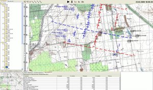
Topographic View
We can make a topographical view as the main view for our trainees. This view looks like a usual topographical map (raster topographic paper scan-based map images are used). Ex-USSR or NATO style topographical signs are used to display actual positions and states of the formations. Real positions of units are used for calculating the position and form (ex-USSR signs have polymorphic form describing shape of a formation position) of these signs with changing the forms and positions of these signs in real time.
Besides, using this type of signs trained officers can give orders to virtual formations in graphical on-map mode.
The topographic view that we make is geodesic anchored and all units in the virtual world have geographical coordinates. All measuring operations can also be made over the topographical map.
Here you can see visualization of formation fight. Blue forces has the orders to attack, red forces – to defense. You can see giving real time orders for blue forces to attack with moving into position and you can see an order for red forces to march to new positions.
Under the map there is virtual world where each unit is modelled simultaneously and it acts due to mission tasks led by artificial intelligence.
In the normal mode a trainee (officer) does not see real positions of all enemy formations (same to the real world), but he can draw signs of their assumed locations based on the information provided by scouts (accompanied by instructors). This allows officers to learn working with a map and scout data and give orders assuming the information they have.
But instructors can see real positions of both sides on the instructor’s topographic map.

