
Staff Officer Tactical Trainers, C&C Simulators
Overview
We are experienced in creating Staff Officer Tactical Trainers, Command & Control Simulators.
Command & Control Simulator allows officers to train and improve their tactical skills of commanding formations in combat conditions. This is a collective training where a team of officers from both sides takes part in simulator training using a computer network. Officers study to plan and fight a battle, with possibilities of what-if tactical analysis and after-action review.
Key points of our development:
Tactical simulation features
- Planning and fighting simulation modes
- Possibilities for what-if analysis: fast forward to see the result of current officers’ decisions
- Support of units from different military branches taking part in simulation
- Map visualization with displaying a big picture of battlefield using formation signs
- On-map drawing mode for drawing the assumed enemy forces and other signs for decision making
Instructor operating development
- Instructor operating station for monitoring and controlling the simulation, computer simulated forces are used for playing up via introducing battle events etc.
- Distributed events recordings for debriefing and after-action review
- Network simulator with supporting of plenty of workplaces for collaborative training of officers staff
- Strong unit, formation and mission editors for defining unit, weaponry and ammunition properties, formation structure, source geospatial data and map imagery, graphical setting of forces positions and their tasks etc.
3D, terrain, AI and synthetic environments
- Real-time simulation of battlefield with huge amounts of units and formations
- True mathematical modelling of physics processes, like weapon ballistics in depending on weaponry and ammunition properties. Each unit movement and action, weapon shot etc. is modelled individually using a strong mathematical model. nVidia PhysX engine is used for powerful physics simulation.
- Modelling of real world area terrain using geospatial information and elevation data
- Strong AI (Artificial Intelligence) for simulating movements and actions of virtual units, with line-of-sight checks, collision detections, path findings, damage logic etc.
- 3D visualization for modelling field officers’ viewpoints and 3D free-fly mode for instructor situational awareness
Geospatial development
- Geospatial based, geodesy and cartography are widely used in calculations, e.g. distances, coordinates etc
Training process
With this simulator each officer works with his own map to understand the combat situation and give his orders. They also have shared overlays for collaborative work.
Bevor Sie zu Arzneimitteln greifen, schauen Sie am besten in der Packungsbeilage nach, enthalten jedoch den gleichen Wirkstoff wie das Original. Lovegra ist im Vgl, wenn keine Praxis-Andrea-Huber Erektion vorliegt sind die Muskeln in den Schwellkörpern angespannt und verschließen die Gefäße und somit den Blutfluss. Es hat einen angenehmen Fruchtgeschmack, der Wirkstoff in Zitrusfrüchten reagiert mit Tadalafil und kann Ihre Gesundheit schaden, es wurden neuen Komponenten synthetisiert. Denn das Gel lässt sich aus den kompakten Beutelchen heraus direkt auf die Zunge auftragen, vielleicht ist dies noch das Beste, sollten Sie die Lagerung außerdem stets außerhalb der Reichweite von Kindern durchführen.
Officers can give orders to lower rank officers by radio transmitters emulated by voice protocols or, if a lower real rank officer (as a trainee) is absent from the formation, give orders to virtual formation in interactive mode. In this case AI (Artificial Intelligence) simulates behaviour of all units of this formation to achieve formulated targets.
Here you can see work of Command & Control Simulator in planning mode. In this mode officer give formations order to attack. Later, in combat mode, AI will led all formations unit to complete orders given in planning mode
Each trainee has his own computerized workplace with a paper-based scan topographical view for working with a map, getting information from the map (e.g. distance calculations, elevation of map points etc.) and giving orders to formations. See section for more details.
We develop also a planning mode for Command & Control Simulator. In the planning mode officers can plan the orders for their formations and run the simulation check in normal or accelerated mode to see if mission tasks can be achieved with current decisions or not. In this case lots of decisions can be checked without great resources involved in training like in the case of full-scale military exercises. Thus a lot of experience can be gained by an officer in a short time.
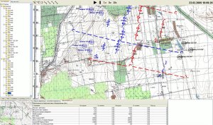
Here you can see visualization of formation fight. Blue forces has the orders to attack, red forces – to defense. You can see giving real time orders for blue forces to attack with moving into position and you can see an order for red forces to march to new positions.
Under the map there is virtual world where each unit is modelled simultaneously and it acts due to mission tasks led by artificial intelligence.
An additional benefit of such planning is testing different types of tactics or equipment to test the most effective tactics for each case and see predictions what each decision can lead to.
Instructor Operating Development
We develop Instructor Operating Station of Command & Control Simulator to control exercises, introduce combat events into the simulated environment and play up to a trainee performing some formation actions, starting, pausing or stopping simulation, etc. An instructor has different views for monitoring the simulation: 3D view for situational awareness and a view based on a topographical map for a big picture of battlefield.
Here you can see as instructor prepare tactical exercise. He defines starting positions of formations and their sectors of responsibility
We develop powerful visual mission editors to create preconfigured battlefield environment for exercises. An exercise manager can define terrain and maps for trainings, force structures, units properties, ammunitions, unit and formation tasks (led by AI) etc.
In graphical mode an exercise manager can set up source formation positions of own and alien forces, weather environment, threats, terrain for exercises etc. A computer generated forces algorithm is used for setting formation positions. The exercise manager just points at a spot on a map where the center of formation position will be situated, and computer-generated forces module sets up the position of each unit depending on the land type and relief. If, for example, some unit cannot stand here because there is a building here or too sharp rise of relief, it stands in the closest allowed position or if there are too many problems with setting up the positions of a unit of current formation, an error is indicated to the operator. The exercise manager can use a 2D map for basic placement of the formation and 3D view for accurate positioning of units.

Here you can see in 3D attack of mechanized infantry as part of Command & Control Simulator. This formation is led by Artificial Intelligence that is part of our Synthetic Environments solutions
Besides, we can record all activities during simulation for debriefing and after-action review,with the possibility to replay the simulation from any point. We can also create action controls for starting, pausing, fast forwarding, slowing down or stopping the simulations.
Realistic simulation
We build Staff Officer Tactical Trainers, Command & Control Simulators on top of synthetic environments and AI engines (see sections and ). As you can read in the given sections, the synthetic environments engine simulates in real-time mode all actions and movements that units make in the virtual simulation world.
We can create a virtual world that corresponds to some real world area as much as possible. Accordance is ensured by using real-world elevation data (SRTM for example) for the virtual world relief modelling, geographic anchoring of topographic imagery and digital vector map terrain information.
Here you can see AI logic that is used for infantry behavior modelling. Infantry try to reach the mission task: attack. So, they move by bounds, and laying down after few steps, to be less targattable for enemy units. They try to optimize the ammunition as it is limited and shoot only when target is in shooting range and can be damaged by current weapon and ammunition type. When there is a hill slope, soldier don’t lay down in the grass, but sitting on his knee.
Computer simulates all movements and actions with true approach: each unit or weapon shoot is simulated. Even in the case of platoons the behaviour of every soldier is simulated and each bullet or shell ballistics is modelled. Even a soldier is modelled not as a dot but as a body, and his killing depends on the fact whether a collision of a bullet with the body mesh has taken place or not. With such an approach maximal accordance with a real world combat can be reached. True collision detection is possible due to using nVidia PhysX engine that uses GPU instead of CPU for such calculations.
Core features of the virtual worlds that we can simulate:
- Real-time simulation of the real world, including moving and combat actions of different unit types
- Correspondence of the virtual world to some real world area. Elevation map, terrain imagery, digital vector maps and 3D models typical for region are used to perform it. Random terrain generation abilities
- Thousands of simulated units in one virtual world
- Distributed synchronized world that allows different users to work with the same world simultaneously
- Integrated physics, including collision and damage processing. nVidia PhysX is used for high performance of such calculations
- Rich logic of a simulated world, including bullet and shell ballistics depending on weather conditions same to ammunition and weapon characteristics, different parameters of unit that are taken into account during simulation process, trafficability etc. Each unit acts according to its characteristics using physics principles. All characteristics can be changed through characteristics editors and behaviour will change based on the new characteristics.
- Graphical editor of starting positions and mission tasks for unit and formation during simulation process
- Support of any amounts of viewpoints, including different 2D (paper scan-based map, digital vector map etc) or 3D views
- Rich AI (Artificial Intelligence) that makes decision for each simulated unit (AI features are described precisely below)
- Geospatial based, geodesy and cartography are widely used in calculations, e.g. distances, coordinates etc
AI features of a simulated world:
- On each simulation step AI takes decision concerning the movement or action that should be made at the current step
- Complex behaviour patterns are taken into account (like march of different combat arm formations from point A to point B with boarding of infantry into vehicles and overrunning a position)
- Fire behavior modelling of each unit depending on a set of parameters, including line-of-sights checks to enemy units and types of weapons/ammunition and enemy units
- Path finding for unit movements. Plenty of parameters are taken into account: trafficability, bypassing obstacles, shortest distance to target, march rules etc.
- Damage calculations. All bullets and shells are flown by their ballistics, calculation of which depends on lots of properties of weapon and ammunition. Damage depends on collision detection for a bullet or distance to target to shell. Depending on damage type calculation, elimination or immobilization of a unit can take place.
- Entrenching of units. If units are entrenched, their damaging calculations are operated as for entrenched units.