
Geospatial programming
We have expertise in development of cartographic software.

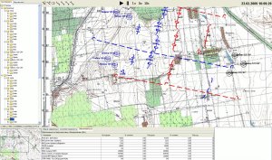
Here you can see vector map diplaying with introducing custom signs over the map and integration of vector map into the application
Here you can see paper map scan that is geodesically anchored to real world
Examples of our services:
- Displaying of vector maps. We have even created our own framework for working with digital vector maps (you can read about it in detail in Extended Vector Maps Framework section). We use vector maps visualization everywhere: in mission editors, for visualizations at air traffic control or instructor operating stations etc.
- Geodesic calculations. For example, in our simulators every object or terrain is geodesically anchored according to the real world with the possibility of different geodesic calculations like distance measuring etc.
- Integration of digital vector maps into applications. For example, we dynamically display current aircraft positions, radar scans, landing beacon visualizations, airfield traffic patterns etc. just over the map in our different simulators. Or we use these maps in mission editors with the customized signs developed in-house for using them on the map
- Raster maps support. For example, we used raster maps for our Command & Control Simulator (for the maps to look the same as the officers have got accustomed). These raster maps were anchored to geographic coordinates same to the virtual world, so we had military signs on the map to visualize current combat environment. In a similar way we used raster maps for mission editors.
With this video you can see as vector map is geographically tied, as coordinates are changed when you move mouse over the map (coordinate values was changed due to demo reasons)